
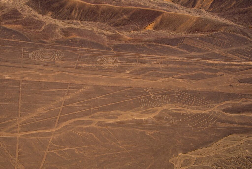
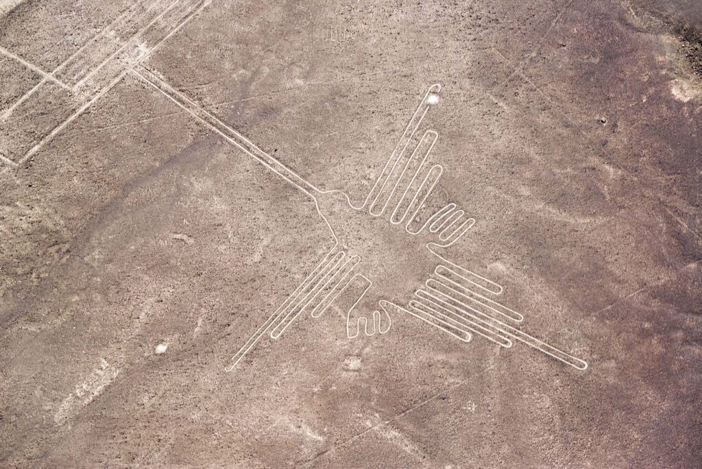
You are in a six-seat Cessna banking hard over a burnt-orange plateau in southern Peru. Below, the desert suddenly resolves into geometry: a hummingbird as long as a city block, a spider nearly as big as a football field, arrows and trapezoids etched with uncanny precision into a plain that has not seen real rain in living memory.
From the cockpit, it is easy to see why the Nazca Lines have become a magnet for UAP-minded visitors. The designs are “best perceived from aerial vantage points,” as one archaeological survey puts it, even though many are also visible from nearby hills.
To some, that aerial vantage point is the punchline: who, before aircraft, could see these forms except “the gods” or visiting non-human intelligences? For others, the lines are the material memory of an advanced Andean culture, a ritualized conversation with mountains, water and stars.
This article treats the Nazca plateau as a living case file: a physical site with hard data, a symbolic landscape and a modern flashpoint in the global discourse on non-human intelligence.
Nazca in numbers: what we can actually measure
Before we jump to sky-vehicles and alien runways, it is worth pinning the basics down.
Core archaeological data
- Location: Arid coastal plain of southern Peru, about 400 km south of Lima, between the towns of Nazca and Palpa on the Pampas de Jumana. (UNESCO World Heritage Centre)
- Extent: Roughly 80 km of high plateau, with the World Heritage core and buffer covering about 75,000 hectares. (UNESCO World Heritage Centre)
- Chronology: Most lines created between roughly 500 BCE and 500 CE, with at least two phases (Paracas and Nazca cultural horizons).
- Motifs:
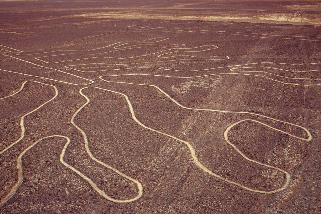
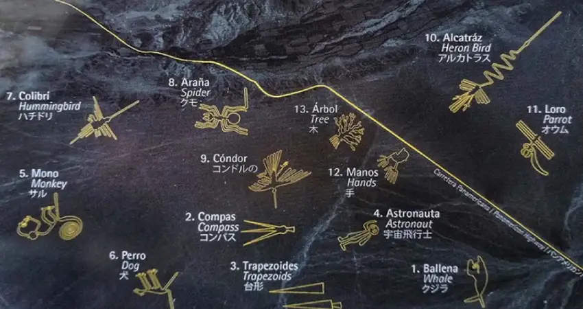
- Over 800 straight lines and hundreds of geometric shapes.
- More than 70 figurative designs (zoomorphs and plants) including hummingbird, monkey, spider, condor, heron, whale, dog, cat and human-like figures.
- Construction method: Dark, iron-oxide–coated desert gravels were scraped aside to expose lighter subsoil, creating durable “negative” drawings. (Kuoda Tours)
- Preservation: Hyper-arid climate, low wind and protective crust of pebbles have kept the designs largely intact for up to two millennia.
Discovery and documentation
- First modern academic notice: Toribio Mejía Xesspe (1927) saw them from the ground while surveying ancient roads.
- Aerial awareness grew in the 1930s as pilots overflew the plateau.
- German-Peruvian mathematician–archaeologist Maria Reiche (“the Lady of the Lines”) began systematic mapping in the 1940s and spent decades lobbying for protection, culminating in UNESCO World Heritage status in 1994.

AI era: the dataset explodes
For most of the twentieth century, only a few hundred figurative geoglyphs were known. That has changed dramatically:
- Between 2004 and 2018, Yamagata University and Peruvian archaeologists identified 190 new geoglyphs using aerial photography and field surveys. (Yamagata University)
- A 2019–2020 drone campaign added 168 more, bringing the documented total to 358. (Yamagata University)
- In 2024, an AI-assisted analysis of high-resolution imagery identified 303 additional figurative geoglyphs in only six months, almost doubling the global count and dramatically accelerating discovery rates. (PNAS)
Many of these newly detected figures are small (around 10 metres), often humanoid or animal “cartoons,” including killer whales holding knives, decapitated heads and strange masked beings that inevitably fuel “alien” interpretations in the popular imagination. (Archaeology News Online Magazine)
The data tell a clear story: the Nazca plateau is not a handful of iconic animals. It is a dense, evolving symbolic and geometric landscape now numbering well over 700 figurative motifs, plus thousands of lines and shapes.
How do you draw a 300-metre hummingbird without satellites?
One of the quiet strengths of the Nazca case is that the engineering problem has been solved in practical experiments.
Archaeologist and archaeoastronomer Anthony Aveni and colleagues, as well as skeptical investigator Joe Nickell, have demonstrated that a small team with very simple tools can reproduce Nazca-scale figures rapidly:
- Aveni describes how a group of 12 people, using broomsticks and string, cleared a “brand-new Nazca line” 20 yards long and 2 yards wide in a single morning. (Unsolved Mysteries)
- Nickell’s team in Kentucky plotted a 440-foot condor by scaling up from a small drawing using only rope, stakes and basic surveying, then clearing vegetation to reveal the pattern.
These experiments match what field archaeology suggests: the Nazca lines were drawn by:
- Creating a small-scale model of the figure.
- Laying out a grid or centerline on the desert using stakes and cords.
- Measuring distances from the centerline or grid points to key outline points.
- Scraping the surface gravels along these plotted curves or straight segments.
No aircraft, balloons or “laser-guided” alien tools are required. The “how” of Nazca is solved with high confidence and supports a human origin.
Claims taxonomy: “Nazca Lines were technically impossible for pre-Columbian people to create without advanced technology”
→ Misidentification. Modern experiments show they are absolutely feasible with simple tools. (Unsolved Mysteries)
What were the Nazca Lines for? Competing human-centered models
Here, the data are more suggestive than conclusive. There is no surviving Nazca text that says “These are runways” or “This is a water ritual circuit.” Researchers are forced to triangulate from ceramics, settlement patterns, offerings and landscape.
Maria Reiche and the celestial calendar
Maria Reiche famously argued that the lines and figures formed a gigantic astronomical calendar mapping solstices, equinoxes and stellar risings, with some animals corresponding to constellations.
Her work was pivotal in raising awareness and protecting the site, but later statistical tests by other scholars found that only a minority of lines align with major celestial events at plausible dates, and that similar alignments could occur by chance in such a large dataset.
Speculation label: Researcher Opinion (mid-20th century archaeoastronomy).
Claims taxonomy: “Nazca Lines are primarily an astronomical observatory” → Disputed.
Interestingly, later archaeoastronomers such as Phyllis Pitluga revived limited alignment claims, for example suggesting the famous spider geoglyph encodes the constellation Orion.
These micro-correlations remain contested, but they keep the sky firmly in the discussion.
Water, mountains and ritual pathways
A growing consensus among Andeanists links the lines to water and pilgrimage:
- Nazca culture engineered underground aqueducts known as puquios that still function today, bringing water across the desert. (Wikipedia)
- Many lines point toward the Andes, where snowmelt feeds Nazca watersheds, and converge at “ray centers” that overlay known water sources or puquio intersections. (Smarthistory)
- Offerings such as marine shells have been found at these convergence points and on nearby mountain summits, suggesting a ritual dialogue between desert, mountains and ocean. (Smarthistory)
Aveni and colleagues argue that:
“The straight lines and trapezoids are related to water … but not used to find water, but rather used in connection with rituals. The trapezoids are big wide spaces where people can come in and out… probably to plead for water.” (Smarthistory)
In this view, the lines are ceremonial processional routes and sacred “paths of power,” with people walking the designs as offerings to water-related deities. The huge animal and plant figures mirror motifs found on Nazca ceramics and textiles, reinforcing their cultural continuity rather than implying outside authorship. (Smarthistory)
Speculation label: Hypothesis (water ritual / pilgrimage model supported by converging but not definitive evidence).
Claims taxonomy: “Nazca Lines are primarily ritual landscapes tied to water and mountain deities” → Probable.
Textiles, looms and mythic codices
Other researchers, such as Henri Stierlin, have suggested that some trapezoids and bands acted as giant textile looms, used symbolically or practically to create long ritual fabrics.
More recent anthropological work frames the entire plateau as a kind of “pictographic creation story,” linking the sequence of figures and paths to myth cycles rather than single functions. (Gale)
Speculation label: Researcher Opinion.
Claims taxonomy: Textile-loom hypothesis → Disputed but grounded in material culture parallels.
Enter the UAP lens: runways for the gods?
From a UAP culture perspective, Nazca entered global consciousness less through academic journals and more through one Swiss author.
Erich von Däniken and the “alien airfield”
In 1968, Erich von Däniken’s bestseller Chariots of the Gods? proposed that:
- The Nazca Lines were “landing strips” for extraterrestrial craft.
- The inhabitants interpreted the visiting ships as “fiery chariots of the gods” and then extended and maintained their tracks as sacred pathways.
Television series such as Ancient Aliens amplified this framing, repeatedly presenting Nazca as one of the “smoking guns” of ancient extraterrestrial contact. (HISTORY)
From a data standpoint, the weaknesses are clear:
- Many lines are too narrow or uneven to function as runways for any high-mass craft.
- The geoglyphs cross slopes and rough terrain unsuitable for landing.
- No associated technological artifacts, exotic materials or anomalous isotopic signatures have been found in situ.
- Similar or even larger geoglyph networks, such as Bolivia’s Sajama Lines, are universally accepted as human ritual constructions.
Nevertheless, the narrative has cultural staying power, in part because it speaks to an intuitive modern sense that Nazca is “meant to be seen from above,” a vantage point we associate with vehicles and flight.
Speculation label: Hypothesis (Ancient-astronaut interpretation).
Claims taxonomy: “Nazca Lines were physically constructed by extraterrestrials or as literal landing strips for craft” → Legend, strongly challenged by archaeology.
Why Nazca feels like a UAP hotspot even without craft
Even if we treat the lines as human, the site behaves like a “high-strangeness hotspot” in several ways:
- It encodes non-ordinary scale and perspective: patterns purposely invisible at ground level but obvious from the “sky being” viewpoint.
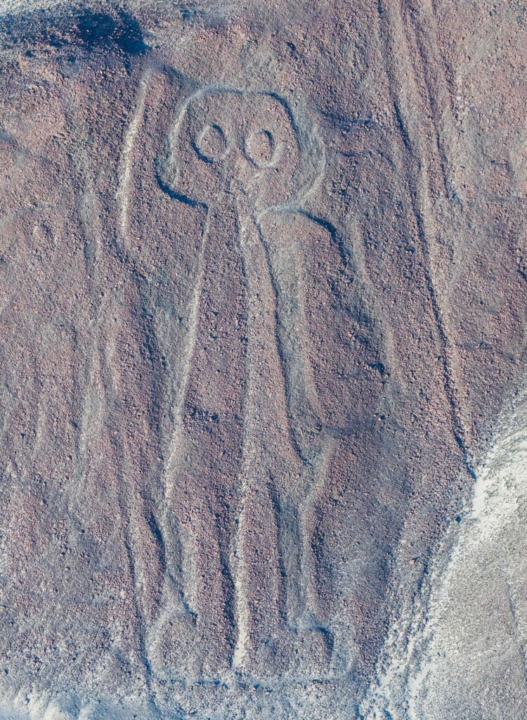
- The iconography includes beings that are neither strictly animals nor humans, including masked figures and the famous “astronaut” geoglyph, a humanoid with disproportionately large eyes raising one hand, which has been read as a sky messenger or star-being in modern narratives.
- Modern UAP culture repeatedly folds Nazca into a wider Andean contact mythology that includes alleged portals (e.g., Marcahuasi), contact groups, and contemporary UAP sightings in Peru investigated by the air force office DIFAA. (VICE)
Peru’s own UAP investigation office has publicly stated that Nazca Lines are not evidence of extraterrestrial construction, framing that stance as part of its mission to “educate the public and dispel common alien myths.” (Fox News)
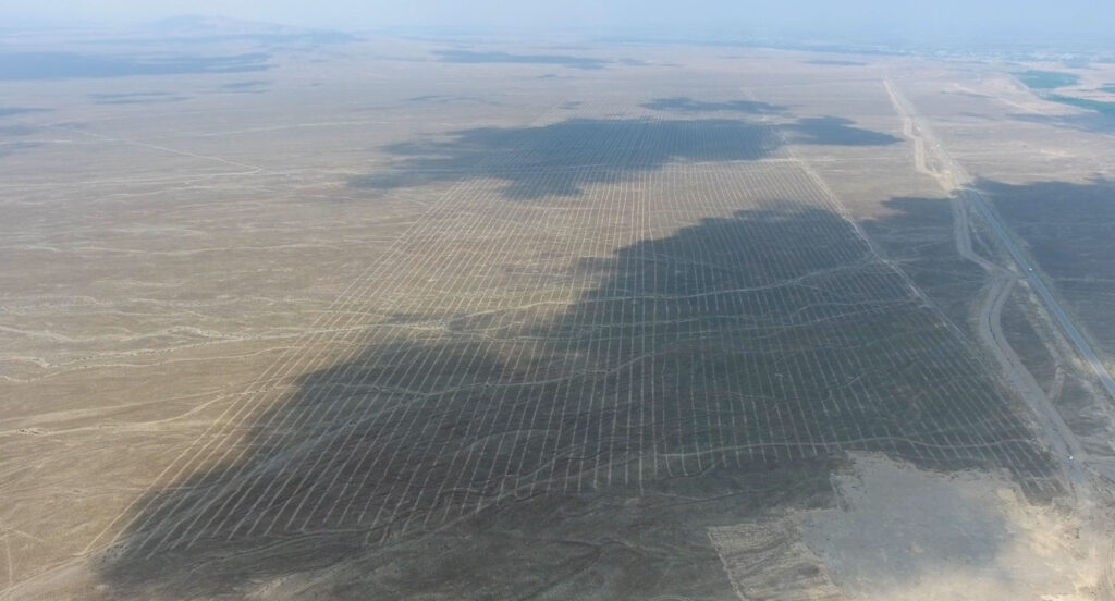
Threats on the ground: highways, activists and miners
The Nazca plateau is not just symbolically fragile. It is physically at risk.
Documented impacts include:
- Construction of the Pan-American Highway, which literally sliced through the tail of the lizard geoglyph and runs along the edge of major figures like the Hands and Tree.
- Vehicle tracks, squatter settlements and quarry machinery that have damaged lines and nearby cemeteries.
- A high-profile 2014 incident in which Greenpeace activists laid a large banner beside the hummingbird figure, leaving footprints and track marks in restricted areas.
- Increasing climate and flood risk, with modelling showing specific geoglyphs, including those near the highway, are vulnerable to rare but devastating runoff events. (arXiv)
In 2025, Peru’s Ministry of Culture briefly reduced the size of the Nazca archaeological park by about 42 percent, triggering a storm of criticism from archaeologists and environmental lawyers, who warned that the downsizing overlapped with zones of illegal and “informal” gold mining. (AP News)
Following domestic and international backlash, the government reversed course and reinstated the full 5,600 km² reserve, promising a multi-stakeholder technical panel and new management scheme. (Reuters)
From a UAPedia editorial standpoint, this is crucial context. Whatever one believes about non-human intelligence, the physical palimpsest that might encode any such interaction is under pressure from very human economic forces.
Nazca, UAP and the bigger Andean picture
Nazca does not sit alone in the Peruvian UAP landscape. A few threads worth flagging for future UAPedia entries and cross-links:
- Peru has an official UAP investigation office, DIFAA, under the air force, periodically revived to respond to waves of anomalous sighting reports. (The Guardian)
- Investigators like Anthony Choy have documented multiple modern cases in coastal and desert regions, and have commented sharply on the misuse of Nazca archaeology in the tridactyl mummies case.
- Andean cosmologies already integrate sky beings, mountain spirits (apus) and water deities in ways that blur modern categories of “religion,” “nature” and “contact.” Nazca’s lines make the most literal and monumental expression of that entanglement. (National Geographic)
Seen through this lens, Nazca is less an isolated “alien airport” and more a giant, vulnerable interface where human ritual behavior, environmental adaptation, symbolic communication and modern UAP culture collide.
Claims taxonomy
- The Nazca Lines were created by the Nazca and related cultures between roughly 500 BCE and 500 CE, using simple surveying and earth-moving techniques.
- Category: Verified
- Evidence: Radiocarbon dating of associated materials, ceramic parallels, stratigraphy, experimental archaeology replicating the techniques. (Wikipedia)
- The primary functions of the lines relate to ritual practices involving water, mountains and pilgrimage.
- Category: Probable
- Evidence: Line orientations to watersheds and mountains, association with puquios and “ray centers” marked by offerings, ethnographic parallels in Andean water and mountain worship. (Smarthistory)
- The lines form a giant astronomical observatory or calendar in a strict technical sense.
- Category: Disputed
- Evidence: Some alignments with solstices and specific stars, but statistical tests show most lines do not correspond cleanly to predictable celestial events. (Latin American Studies)
- Nazca Lines were constructed as landing strips or navigational aids for extraterrestrial craft.
- Category: Legend
- Evidence: Proposed in ancient-astronaut literature and popular media, but contradicted by the lines’ physical characteristics, lack of associated high-technology artifacts and strong evidence for human construction. (Wikipedia)
- Illegal grave-robbing and antiquities trafficking in the Nazca region are being fuelled by global “alien” narratives.
- Category: Verified
- Evidence: On-the-ground reporting from Reuters and other outlets linking demand for “alien” relics to increased looting around Nazca. (Reuters)
Speculation labels
Hypothesis
- Water-ritual / pilgrimage interpretation of many lines and trapezoids.
- Limited celestial alignment models (e.g., specific constellations encoded in certain figures).
Researcher Opinion
- Maria Reiche’s comprehensive astronomical calendar model.
- Textile-loom interpretations of certain trapezoids.
- “Creation story” reading of sequences of figures across the pampa.
Witness Interpretation
- Tour guide and visitor narratives that frame the “astronaut” figure and new AI-found humanoids as depictions of star visitors or non-human entities. These are culturally important but not evidential by themselves.
UAPedia treats all three as valuable but distinct from the Verified and Probable tiers above.
References
Aveni, A. (2001). Nasca Lines: A new perspective on their origin and meaning. (Various essays and lectures). See summary discussion in Smarthistory. smarthistory.org/nazca-nasca-art-sacred-linearity-bold-designs/utm_source=uapedia.ai (Smarthistory)
Centre, UNESCO World Heritage. (n.d.). Lines and Geoglyphs of Nasca and Palpa. whc.unesco.org/en/list/700/utm_source=uapedia.ai (UNESCO World Heritage Centre)
Golomb, J. (2010). Why the Nasca lines are among Peru’s greatest mysteries. National Geographic. www.nationalgeographic.com/history/article/nasca-lines/utm_source=uapedia.ai (National Geographic)
Jarus, O. (2022). Nazca Lines: Mysterious geoglyphs in Peru. Live Science. www.livescience.com/22370-nazca-lines.html/utm_source=uapedia.ai
Sakai, M., et al. (2024). AI-accelerated Nazca survey nearly doubles the number of figurative geoglyphs. Proceedings of the National Academy of Sciences. www.pnas.org/doi/10.1073/pnas.2407652121?utm_source=uapedia.ai (PNAS)
Smarthistory. (2016). Nasca geoglyphs. smarthistory.org/nasca-geoglyphs/utm_source=uapedia.ai (Smarthistory)
Vox / Romano, A. (2023). The true story of the fake unboxed aliens is wilder than actual aliens. www.vox.com/culture/23875671/aliens-mexican-congress-peru-nazca-mummies?utm_source=uapedia.ai (Vox)
Yamagata University Institute of Nasca. (2022). 168 new geoglyphs discovered on the Nasca Pampa and surrounding areas. www.yamagata-u.ac.jp/en/information/info/20221208/utm_source=uapedia.ai (Yamagata University)
These should be complemented with Spanish-language sources from Peruvian cultural agencies and critical Andean scholarship for any deep-dive research.
SEO keywords
Nazca Lines UAP, Nazca Lines UFO, Nazca Lines aliens, Nazca desert geoglyphs, Peru UAP investigations, DIFAA Peru, Nazca alien mummies, tridactyl Nazca mummies, Maria Reiche Nazca, Anthony Aveni water rituals, ancient astronauts Nazca, Nazca Lines AI discovery, Nazca Lines map, high-strangeness hotspots Peru, Nazca Lines UNESCO, Nazca puquios and geoglyphs